파일:MH370 flight path with English labels.png

미리 보기 크기: 730 × 600 픽셀 다른 해상도: 292 × 240 픽셀 | 584 × 480 픽셀 | 935 × 768 픽셀 | 1,246 × 1,024 픽셀 | 1,934 × 1,589 픽셀
원본 파일 (1,934 × 1,589 픽셀, 파일 크기: 654 KB, MIME 종류: image/png)
파일 설명
| 설명 |
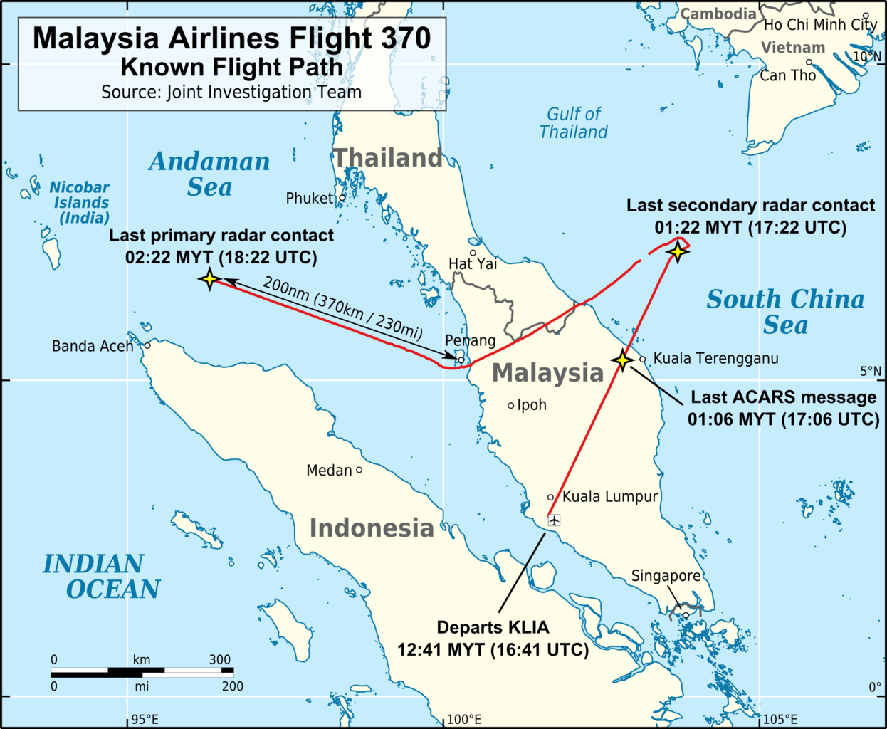
English: Map of the flight path of Malaysia Airlines Flight 370. |
|||
| 날짜 | ||||
| 출처 |
자작 Flight path traced from a map ("Figure 2: MH370 flight path derived from primary and secondary radar data") on page 3 of the report MH 370 – Definition of Underwater Search Areas published by the Australian Transport Safety Bureau. The source map is in simple cylindrical projection (from Google Earth) and was gereferenced and distorted into a flat Mercator projection before being traced for this map. The data in the source image (ie. the flight path) that was traced to generate this map is the location of Flight 370. The position of an object is a fact; facts cannot be copyrighted. Background is the "Simplified World Polygons (LSIB) - March 2013" dataset available from the US Department of State - Office of the Geographer (public domain). Map boundaries: 93°E-107°E & 0.5°S-11°N. |
|||
| 저자 | AHeneen | |||
| 저작권 (이 파일을 인용하기) |
나는 아래 작품의 저작권자로서, 이 저작물을 다음과 같은 라이선스로 배포합니다: 이 파일은 크리에이티브 커먼즈 저작자표시 3.0 Unported 라이선스로 배포됩니다.
|
|||
| 다른 버전 |
|


파일 역사
날짜/시간 링크를 클릭하면 해당 시간의 파일을 볼 수 있습니다.
| 날짜/시간 | 섬네일 | 크기 | 사용자 | 설명 | |
|---|---|---|---|---|---|
| 현재 | 2014년 12월 13일 (토) 08:45 | | 1,934 × 1,589 (654 KB) | wikimediacommons>AHeneen | Larger font size for the four event labels & change size of scale |
이 파일을 사용하는 문서
다음 문서 1개가 이 파일을 사용하고 있습니다: